TM 5-6675-318-14
Table 4-8. CODE 73 DISPLAYS FOR TRANSLOCATION POSITION - Cont
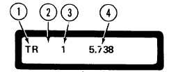
I n i t i a l D i s p l a y
1.
Translocation code mnemonic (TR).
2.
When this position is blank, the translocation position was computed using
d a t a f r o m t h e l a s t s a t e l l i t e p a s s.
A o n e - l e t t e r c o d e i n t h i s p o s i t i o n i n d i c a t e s
that the last pass data was not used.
The following codes signify the reason for
not using data from the last pass:
0 -
C -
D -
E -
H -
I -
R -
S -
U -
X -
Y -
3.
4.
No 2D fix could be computed.
Less than eight doppler counts used in 2D computations.
More than 1 km (0.62 miles) between 2D position and reference position.
M a x i m u m e l e v a t i o n a n g l e o f s a t e l l i t e l e s s t h a n 1 5 d e g r e s s .
Maximum elevation angle greater than 70 degrees immediately after point
position was reset.
More than six iterations occurred in 2D computation.
Only one of two satellite receiver channels was used to calculate 2D position
due to insufficient data on other channel.
S t a n d a r d d e v i a t i o n o f r e s i d u a l s w a s t o o l a r g e , i n d i c a t i n g t h a t s a t e l l i t e d a ta
was in error (see code 91).
Data from satellite was asymmetrical about point of closest approach.
L a s t s a t e l l i t e p a s s d a t a w a s t a k e n f r o m a s a t e l l i t e t h a t i n d i c a t e d w i t h i n i ts
message that it should not be used for precise applications (i.e., negative
s a t e l i t e n u m b e r ) .
Satellite pass data was taken from a satellite that was deleted by user.
Number of satellite passes used in the translocation position computation.
Distance in meters from the previously computed translocation position.
This value is meaningless for the first computation.
Press the enter (E) key.
Display shows the computed latitude in degrees, minutes,
and seconds using satellite datum coordinates.
4-73