TM 5-6675-318-14
Table 4-10. CODE 77 DISPLAYS FOR INPUT POSITION - Cont
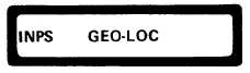
Geographic position entry .
The user may select geographic position entry in either
the satellite datum or a local datum.
Before selecting local datum, specify con-
stants identifying the local datum using code 100 (refer to paragraph 4-6.3.4).
Geodetic Satellite Datum Selected
Geodetic Local Datum Selected
The first parameter to be displayed and/or entered is the latitude in degrees,
m i n u t e s , a n d s e c o n d s o f t h e i n p u t p o s i t i o n . I f t h e c u r r e n t l y d i s p l a y e d v a l u e is
c o r r e c t , p r e s s o n l y t h e e n t e r ( E ) k e y . I f i t i s n o t c o r r e c t , e n t e r t h e n e w v a l u e.
Enter a space between degrees and minute, and between minutes and seconds.
Use the +/- key to change from N (north) to S (south) or vice versa. Then press the
enter (E) key to enter the latitude.
L a t i t u de
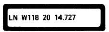
The next parameter to be displayed and/or entered is the longitude in degrees,
minutes, and seconds of the input position.
I f t h e c u r r e n t l y d i s p l a y e d v a l u e is
correct, press only the enter (E) key.
I f i t i s n o t c o r r e c t , e n t e r t h e n e w v a l u e .
Enter a space
between degrees and minutes, and between minutes and seconds.
Use the +/- key to change from E (east) to W (west) or vice versa. Then press the
enter (E) key to enter the new longitude.
Longitude
4-82 Change 3