TM 5-6675-318-14
Table 4-5. CODE 53 DISPLAYS FOR LAST PASS 2D POSITION
Enter code 53 to display the last satellite pass and two dimensional position. The
two dimensional position computation is based only on data from the last pass. The
data is displayed in a sequence of seven displays.
Press the enter (E) key to erase
one display and view the next.
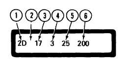
T h e i n i t i a l d i s p l a y s h o w s t h e f o l l o w i ng
i n f o r m a t i o n :
I n i t i a l D i s p l a y
1.
Two dimensional (2D) code mnemonic.
2. When this position is blank, both of the 150 MHz and 400 MHz channels were
used in the computation.
A 1 in this position indicates that only the 150 MHz
channel was used; a 4 indicates that only the 400 MHz channel was used.
3.
Maximum elevation angle of the satellite above the horizon in degrees. A
zero indicates no position was computed.
4.
Number of iterations in the 2D computation.
5. Number of 23/28 second doppler counts used in the computation.
6.
L a s t t h r e e d i g i t s o f t h e s a t e l l i t e i d e n t i f i c a t i o n n u m b e r .
Press the enter (E) key.
Display shows the geometry of the pass and the standard
deviation of the doppler count residuals in meters. The geometry gives the
direction of satellite travel at closest approach (N = north, S = south) followed by
the position of the satellite at closest approach (E = east, W = west) with respect
t o t h e s i t e .
Geometry and Standard Deviation of Residuals
Press the enter (E) key.
Display shows the computed latitude in degrees, minutes,
and seconds in satellite datum coordinates.
4-62